Geolocate

Nectar topographic map

Click on the map to display elevation.

About this map

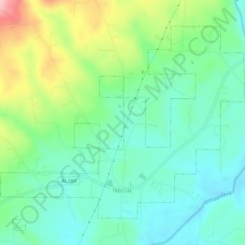
Name: Nectar topographic map, elevation, terrain.

Location: Nectar, Blount County, Alabama, United States (33.95551 -86.66146 33.98438 -86.61733)

Average elevation: 178 m

Minimum elevation: 121 m

Maximum elevation: 312 m

Other topographic maps

Click on a map to view its topography, its elevation and its terrain.

Summit

United States > Alabama > Blount County

Average elevation: 260 m

Royal

United States > Alabama > Blount County

Average elevation: 234 m

Woodhaven

United States > Alabama > Blount County

Average elevation: 255 m

Appalachian

United States > Alabama > Blount County

Average elevation: 324 m

Snead

United States > Alabama > Blount County

Average elevation: 238 m

Appalachian

United States > Alabama > Blount County

Average elevation: 324 m

Sulpher Springs

United States > Alabama > Blount County

Average elevation: 129 m

Raccoon Mountain

United States > Alabama > Blount County

Average elevation: 326 m

Appalachian

United States > Alabama > Blount County

Average elevation: 324 m

Nyota

United States > Alabama > Blount County

Average elevation: 142 m

Gear up for your next adventure:

🥾All-Terrain Hiking Boots - Versatile boots for varied hiking conditions
👟Sport Hiking Sandals - Breathable footwear for water crossings and camp rest
🧥Packable Rain Jacket - Breathable waterproof layer for unpredictable weather
🧦Merino Wool Socks - Moisture-wicking comfort for long-distance hiking
🥾Trail Hiking Shoes - Durable shoes designed for rugged trails

As an Amazon Associate, this site earns from qualifying purchases at no extra cost to you.