Geolocate

Troon topographic map

Click on the map to display elevation.

About this map

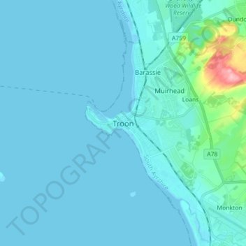
Name: Troon topographic map, elevation, terrain.

Location: Troon, South Ayrshire, Scotland, KA10 6AZ, United Kingdom (55.50379 -4.70391 55.58379 -4.62391)

Average elevation: 11 m

Minimum elevation: -1 m

Maximum elevation: 149 m

Other topographic maps

Click on a map to view its topography, its elevation and its terrain.

Gear up for your next adventure:

💧Filtered Water Bottle - Safe drinking water on the go
🧣Evaporative Cooling Towel - Beat the heat during intense summer climbs
🥾Waterproof Hiking Shoes - Durable shoes for wet and rugged trails
🧤Insulated Winter Gloves - Heavy-duty protection for sub-zero Canadian adventures
🥾Mountain Hiking Boots - High-traction boots for rocky terrain

As an Amazon Associate, this site earns from qualifying purchases at no extra cost to you.