Geolocate

James topographic map

Click on the map to display elevation.

About this map

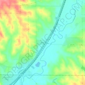
Name: James topographic map, elevation, terrain.

Location: James, Plymouth County, Iowa, 51204, United States (42.55700 -96.33758 42.59700 -96.29758)

Average elevation: 364 m

Minimum elevation: 332 m

Maximum elevation: 424 m

Other topographic maps

Click on a map to view its topography, its elevation and its terrain.

Merrill

United States > Iowa > Plymouth County

Average elevation: 367 m

Akron

United States > Iowa > Plymouth County

Average elevation: 359 m

Le Mars

United States > Iowa > Plymouth County

Average elevation: 386 m

Kingsley

United States > Iowa > Plymouth County

Average elevation: 386 m

Hinton

United States > Iowa > Plymouth County

Average elevation: 362 m

Hinton

United States > Iowa > Plymouth County

Average elevation: 362 m

Akron

United States > Iowa > Plymouth County

Average elevation: 359 m

Kingsley

United States > Iowa > Plymouth County

Average elevation: 386 m

Gear up for your next adventure:

🧢Beanie Hat - Keep your head warm in cold weather
Camping Tent - Weather-resistant tents suitable for 2 to 6 people
🧭GPS Handheld Device - Reliable GPS navigation for outdoor adventures
🏕️Camping Hammock - Integrated protection for sleeping between trees
💡Portable Camping Lamp - Rechargeable lamp for campsite lighting

As an Amazon Associate, this site earns from qualifying purchases at no extra cost to you.