Geolocate

Hinton topographic map

Click on the map to display elevation.

About this map

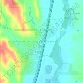
Name: Hinton topographic map, elevation, terrain.

Location: Hinton, Plymouth County, Iowa, 51204, United States (42.61197 -96.30898 42.63378 -96.28744)

Average elevation: 362 m

Minimum elevation: 341 m

Maximum elevation: 415 m

Other topographic maps

Click on a map to view its topography, its elevation and its terrain.

James

United States > Iowa > Plymouth County

Average elevation: 364 m

Gear up for your next adventure:

🧦Hiking Liner Socks - Thin base layer to prevent friction and blisters
🧼Biodegradable Camp Soap - Environmentally friendly cleaning for gear and body
🧰Survival Kit - Essential gear for emergencies in the wilderness
🧣Merino Neck Gaiter - Protects against wind, sun, and cold at high altitudes
🌬️Windproof Camp Stove - Efficient cooking even on exposed mountain peaks

As an Amazon Associate, this site earns from qualifying purchases at no extra cost to you.