Geolocate

Akron topographic map

Click on the map to display elevation.

About this map

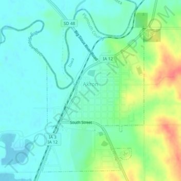
Name: Akron topographic map, elevation, terrain.

Location: Akron, Plymouth County, Iowa, United States (42.81570 -96.56782 42.83997 -96.54707)

Average elevation: 359 m

Minimum elevation: 342 m

Maximum elevation: 398 m

Gear up for your next adventure:

👟Sport Hiking Sandals - Breathable footwear for water crossings and camp rest
🔋Emergency Crank Radio - Weather alerts and power without needing batteries
🧥Ultralight Puffy Jacket - Maximum warmth that packs down to the size of an orange
🧰Survival Kit - Essential gear for emergencies in the wilderness
🥾Trail Hiking Boots - Supportive boots for rough trails

As an Amazon Associate, this site earns from qualifying purchases at no extra cost to you.