
Village of Clyde topographic map
Interactive map
Click on the map to display elevation.
About this map
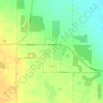
Name: Village of Clyde topographic map, elevation, terrain.
Location: Village of Clyde, Division No. 13, Alberta, Canada (54.14462 -113.65028 54.15577 -113.61301)
Average elevation: 651 m
Minimum elevation: 634 m
Maximum elevation: 664 m
Other topographic maps
Click on a map to view its topography, its elevation and its terrain.
Roselea Natural Area
Canada > Alberta > Division No. 13
Roselea Natural Area, Range Road 54, Division No. 13, Alberta, Canada
Average elevation: 682 m
Village of Alberta Beach
Canada > Alberta > Division No. 13
Village of Alberta Beach, Division No. 13, Alberta, T0E 0A0, Canada
Average elevation: 728 m
Town of Athabasca
Canada > Alberta > Division No. 13
Town of Athabasca, Division No. 13, Alberta, Canada
Average elevation: 566 m
Sangudo
Canada > Alberta > Division No. 13
Sangudo, Division No. 13, Alberta, T0E 2A0, Canada
Average elevation: 687 m