
Washington County topographic map
Click on the map to display elevation.
Washington County
The economy of Washington County was based on apples in the late 19th century. A mixture of wet weather, altitude, and loamy soils provided a good environment for apple orchards. First planted in areas around Lincoln, Evansville, and Cane Hill in the 1830s, apple orchards began all across the county. The United States Census reported a crop of 614,924 bushels of apples produced by the county in 1900, the highest in the state. Several varieties of apple were discovered in the area including Shannon Pippin, Wilson June, and most notably the Arkansas Black. The Ben Davis became the apple of choice in the area for sale and shipment across the region. Corn became the dominant crop, outselling apples by almost $500,000 in 1900.
About this map
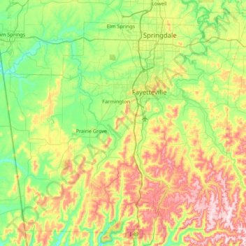
Name: Washington County topographic map, elevation, terrain.
Location: Washington County, Arkansas, United States (35.75031 -94.55217 36.23824 -93.88827)
Average elevation: 424 m
Minimum elevation: 272 m
Maximum elevation: 738 m
Other topographic maps
Click on a map to view its topography, its elevation and its terrain.
Mount Magazine State Park
United States > Arkansas > Logan County
There also exist many opportunities for ATV riding, backpacking, hang gliding, mountain biking, rappelling, and rock climbing within the park. The park hosts the annual Mount Magazine International Butterfly Festival, and is a haven for many rare species of butterflies in Arkansas due to the special blend of…
Average elevation: 667 m
Thorn Crown Chapel
United States > Arkansas > Carroll County > Eureka Springs
Average elevation: 390 m
Sweetwater Estates
United States > Arkansas > Lonoke County > Ward > Sweetwater Estates
Average elevation: 85 m
Willow Beach Lake Dam
United States > Arkansas > Pulaski County > North Little Rock
Average elevation: 73 m