
Make a donation
Gear up for your next adventure:
As an Amazon Associate, this site earns from qualifying purchases at no extra cost to you.
DeKalb County topographic map
Click on the map to display elevation.
Make a donation
Gear up for your next adventure:
As an Amazon Associate, this site earns from qualifying purchases at no extra cost to you.
About this map
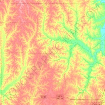
Name: DeKalb County topographic map, elevation, terrain.
Location: DeKalb County, Missouri, United States (39.74326 -94.60618 40.03833 -94.20534)
Average elevation: 295 m
Minimum elevation: 240 m
Maximum elevation: 338 m
Make a donation
Gear up for your next adventure:
As an Amazon Associate, this site earns from qualifying purchases at no extra cost to you.
Other topographic maps
Click on a map to view its topography, its elevation and its terrain.
Make a donation
Gear up for your next adventure:
As an Amazon Associate, this site earns from qualifying purchases at no extra cost to you.
Make a donation
Gear up for your next adventure:
As an Amazon Associate, this site earns from qualifying purchases at no extra cost to you.
Make a donation
Gear up for your next adventure:
As an Amazon Associate, this site earns from qualifying purchases at no extra cost to you.
Saint Clair
United States > Missouri > Franklin County > St. Clair > Saint Clair
Average elevation: 210 m
Mary Ridge
United States > Missouri > Saint Louis County > Breckenridge Hills
Average elevation: 187 m
Salem Rd Mobile Home Community
United States > Missouri > Taney County > Salem Rd Mobile Home Community
Average elevation: 368 m
Make a donation
Gear up for your next adventure:
As an Amazon Associate, this site earns from qualifying purchases at no extra cost to you.
Make a donation
Gear up for your next adventure:
As an Amazon Associate, this site earns from qualifying purchases at no extra cost to you.