Geolocate

Almaguer topographic map

Click on the map to display elevation.

About this map

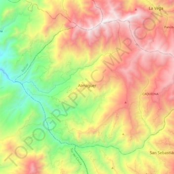
Name: Almaguer topographic map, elevation, terrain.

Location: Almaguer, Macizo, Cauca, Colombia (1.83653 -76.93618 1.98811 -76.74044)

Average elevation: 2,102 m

Minimum elevation: 882 m

Maximum elevation: 3,454 m

Other topographic maps

Click on a map to view its topography, its elevation and its terrain.

Toscana Circle

Colombia > Cauca > Popayán

Average elevation: 1,735 m

Torres

Colombia > Cauca > La Sierra

Average elevation: 1,759 m

Rio Negro

Colombia > Cauca > Puracé

Average elevation: 3,199 m

MONDOMO

Colombia > Cauca > Santander de Quilichao

Average elevation: 1,397 m

Peña Del Condado

Colombia > Cauca > Silvia > Peña Del Condado

Average elevation: 2,922 m

Páramo de Santo Domingo

Colombia > Cauca > Toribío

Average elevation: 3,886 m

El Condor

Colombia > Cauca > El Condor

Average elevation: 1,950 m

Inzá

Colombia > Cauca > Inzá > Inzá

Average elevation: 1,876 m

Gear up for your next adventure:

🚑Survival Whistle - Signal for help across long distances in mountains
🍽️Titanium Camping Spork - Ultralight and indestructible eating utensil
🧴Insect Repellent - Protect yourself from bugs during outdoor adventures
🚲Handlebar Phone Mount - View topographic-map.com live while cycling
🧥Waterproof Jacket - Lightweight rain jackets for hiking and outdoor activities

As an Amazon Associate, this site earns from qualifying purchases at no extra cost to you.