Geolocate

Licata topographic map

Click on the map to display elevation.

About this map

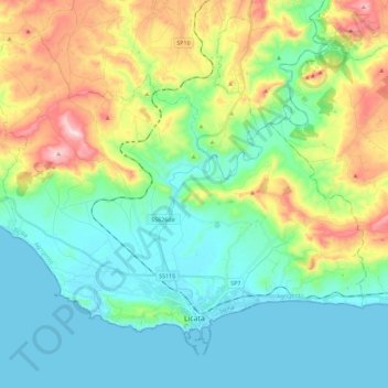
Name: Licata topographic map, elevation, terrain.

Location: Licata, Agrigento, Sicily, 92027, Italy (37.08448 13.81082 37.23475 14.03861)

Average elevation: 128 m

Minimum elevation: -2 m

Maximum elevation: 462 m

Other topographic maps

Click on a map to view its topography, its elevation and its terrain.

Agrigento

Italy > Sicily > Agrigento > Agrigento

Average elevation: 187 m

Linosa

Italy > Sicily > Agrigento

Average elevation: 9 m

Contrada Capo

Italy > Sicily > Agrigento > Caldare

Average elevation: 360 m

Punta Bianca

Italy > Sicily > Agrigento > Agrigento

Average elevation: 25 m

Contrada Spinasanta

Italy > Sicily > Agrigento > Aragona

Average elevation: 218 m

Monte Narbone

Italy > Sicily > Agrigento > Agrigento

Average elevation: 302 m

Gear up for your next adventure:

🔥Emergency Fire Starter - Reliable ignition source for all weather conditions
🛁Quick-Dry Microfiber Towel - Space-saving towel that dries rapidly on the move
🛶Canoe Life Vest - Safety vest for water sports
🥾Trail Running Shoes - Lightweight and durable shoes for trail running
🥽Outdoor Goggles - Protective eyewear for outdoor activities

As an Amazon Associate, this site earns from qualifying purchases at no extra cost to you.