Geolocate

Agrigento topographic map

Click on the map to display elevation.

About this map

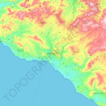
Name: Agrigento topographic map, elevation, terrain.

Location: Agrigento, Sicily, 92100, Italy (37.15230 13.41465 37.47230 13.73465)

Average elevation: 187 m

Minimum elevation: 0 m

Maximum elevation: 652 m

Gear up for your next adventure:

🥽Outdoor Goggles - Protective eyewear for outdoor activities
🛌Insulated Sleeping Pad - Critical thermal barrier between you and the cold ground
🧥Thermal Layer - Insulating layer for cold outdoor conditions
🧭GPS Outdoor Watch - Smart watch for navigation and fitness tracking in nature
🧢Sun Hat - Wide-brim hat for sun protection

As an Amazon Associate, this site earns from qualifying purchases at no extra cost to you.