Geolocate

Stubbington topographic map

Click on the map to display elevation.

About this map
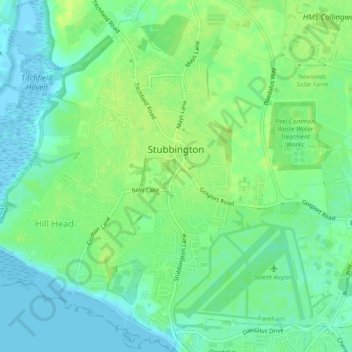
Name: Stubbington topographic map, elevation, terrain.

Location: Stubbington, Fareham, Hampshire, England, United Kingdom (50.80894 -1.24424 50.83841 -1.20630)

Average elevation: 8 m

Minimum elevation: -5 m

Maximum elevation: 15 m

Other topographic maps

Click on a map to view its topography, its elevation and its terrain.

Titchfield

United Kingdom > England > Hampshire > Fareham

Average elevation: 23 m

Park Gate

United Kingdom > England > Hampshire > Fareham

Average elevation: 30 m

Dibden

United Kingdom > England > Hampshire > New Forest

Average elevation: 17 m

Farnborough

United Kingdom > England > Hampshire > Rushmoor

Farnborough is located in the northeastern corner of the county of Hampshire, near the border with Surrey. The town occupies a valley setting, with the main urban area situated between the River Blackwater to the east and higher ground to the west. The topography gradually rises from the valley floor, reaching…

Average elevation: 82 m

Brook

United Kingdom > England > Hampshire > New Forest > Bramshaw

Average elevation: 65 m

Odiham

United Kingdom > England > Hampshire > Hart > Odiham

Average elevation: 107 m

Flagpond Copse

United Kingdom > England > Hampshire > Winchester

Average elevation: 26 m

North Fareham

United Kingdom > England > Hampshire > Fareham

Average elevation: 27 m

Winsor

United Kingdom > England > Hampshire > New Forest

Average elevation: 27 m

Gear up for your next adventure:

🥾Trail Hiking Boots - Supportive boots for rough trails
🧤Thermal Hiking Gloves - Grip-enhanced gloves for cold-weather altitude trekking
🌡️Emergency Mylar Blankets - Compact thermal protection for unexpected nights outdoors
🧦Thermal Socks - Warm socks for winter hiking or camping
🧤Insulated Winter Gloves - Heavy-duty protection for sub-zero Canadian adventures

As an Amazon Associate, this site earns from qualifying purchases at no extra cost to you.