Geolocate

Flagpond Copse topographic map

Click on the map to display elevation.

About this map

Name: Flagpond Copse topographic map, elevation, terrain.

Location: Flagpond Copse, Whiteley, Winchester, Hampshire, England, PO15 6DY, United Kingdom (50.87482 -1.23611 50.89482 -1.21611)

Average elevation: 26 m

Minimum elevation: 7 m

Maximum elevation: 58 m

Other topographic maps

Click on a map to view its topography, its elevation and its terrain.
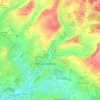
Whiteley

United Kingdom > England > Hampshire > Winchester

Average elevation: 27 m

Tichborne

United Kingdom > England > Hampshire > Winchester

Average elevation: 102 m

Gear up for your next adventure:

🥾Lightweight Hiking Shoes - Comfortable shoes for day hikes
🧢Outdoor Cap - Protective cap for sun and rain during hikes
🥽Outdoor Goggles - Protective eyewear for outdoor activities
🧴Bear Spray Holster - Quick-access carry for essential Canadian wilderness safety
🧥Thermal Fleece Jacket - Versatile insulation for changing mountain temperatures

As an Amazon Associate, this site earns from qualifying purchases at no extra cost to you.