Geolocate

Dalig topographic map

Click on the map to display elevation.

About this map
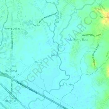
Name: Dalig topographic map, elevation, terrain.

Location: Dalig, Balagtas, Bulacan, Central Luzon, 3016, Philippines (14.82085 120.90139 14.86085 120.94139)

Average elevation: 7 m

Minimum elevation: 2 m

Maximum elevation: 26 m

Other topographic maps

Click on a map to view its topography, its elevation and its terrain.
Balagtas River

Philippines > Bulacan > Balagtas

Average elevation: 6 m

Santol

Philippines > Bulacan > Balagtas

Average elevation: 7 m

Longos

Philippines > Bulacan > Balagtas

Average elevation: 5 m

Wawa

Philippines > Bulacan > Balagtas

Average elevation: 4 m

Panginay

Philippines > Bulacan > Balagtas

Average elevation: 4 m

Wawa

Philippines > Bulacan > Balagtas

Average elevation: 4 m

Gear up for your next adventure:

🧤Rechargeable Heated Gloves - Extreme warmth for Canadian winter expeditions
🧥Packable Rain Jacket - Breathable waterproof layer for unpredictable weather
🛌Insulated Sleeping Pad - Critical thermal barrier between you and the cold ground
🔋Emergency Crank Radio - Weather alerts and power without needing batteries
💧Collapsible Water Bottle - Space-saving water bottle for outdoor activities

As an Amazon Associate, this site earns from qualifying purchases at no extra cost to you.