Geolocate

Minto topographic map

Click on the map to display elevation.

About this map
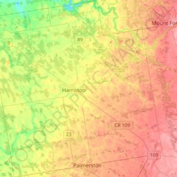
Name: Minto topographic map, elevation, terrain.

Location: Minto, Wellington County, Southwestern Ontario, Ontario, Canada (43.82208 -80.99150 44.00432 -80.74180)

Average elevation: 392 m

Minimum elevation: 342 m

Maximum elevation: 434 m

Other topographic maps

Click on a map to view its topography, its elevation and its terrain.
Elora

Canada > Ontario > Wellington County > Centre Wellington

Average elevation: 395 m

Eramosa

Canada > Ontario > Wellington County > Guelph/Eramosa

Average elevation: 361 m

Gear up for your next adventure:

💡Solar Camping Lamp - Eco-friendly lighting for campsites
❄️Traction Ice Cleats - Slip-on spikes for icy trails and winter hiking
🛰️Satellite Messenger - Emergency communication for areas with no cell service
🧥Fleece Jacket - Warm and lightweight jacket for layering
🥘Camping Cookware Set - Compact nesting pots and pans for trail cooking

As an Amazon Associate, this site earns from qualifying purchases at no extra cost to you.