Geolocate

Matanzas topographic map

Click on the map to display elevation.

About this map
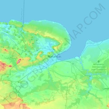
Name: Matanzas topographic map, elevation, terrain.

Location: Matanzas, Cuba (22.95191 -81.75083 23.15366 -81.40643)

Average elevation: 54 m

Minimum elevation: 0 m

Maximum elevation: 367 m

Other topographic maps

Click on a map to view its topography, its elevation and its terrain.

Yugoslavia

Cuba > Matanzas > Matanzas

Average elevation: 15 m

Yugoslavia

Cuba > Matanzas > Matanzas

Average elevation: 15 m

Maneadero

Cuba > Matanzas > Ciénaga de Zapata

Average elevation: 2 m

Zapato

Cuba > Matanzas > Martí

Average elevation: 13 m

Indio Hatuey

Cuba > Matanzas > Perico

Average elevation: 23 m

Cayo Buba

Cuba > Matanzas > Varadero

Average elevation: 0 m

Gear up for your next adventure:

🔥Emergency Fire Starter - Reliable ignition source for all weather conditions
🛶Waterproof Dry Bags - Keep electronics and clothes dry during river crossings
🌡️Emergency Mylar Blankets - Compact thermal protection for unexpected nights outdoors
🧦Crew Hiking Socks - Comfortable socks for long-distance hikes
🧴Insect Repellent - Protect yourself from bugs during outdoor adventures

As an Amazon Associate, this site earns from qualifying purchases at no extra cost to you.