Geolocate

Watsonville topographic map

Click on the map to display elevation.

About this map

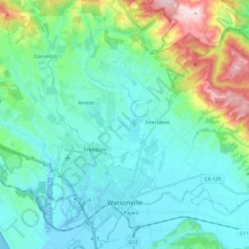
Name: Watsonville topographic map, elevation, terrain.

Location: Watsonville, Santa Cruz County, California, United States (36.88406 -121.82732 37.01911 -121.73234)

Average elevation: 117 m

Minimum elevation: -3 m

Maximum elevation: 587 m

Other topographic maps

Click on a map to view its topography, its elevation and its terrain.

Felton

United States > California > Santa Cruz County

Average elevation: 218 m

Gordola

United States > California > Santa Cruz County

Average elevation: 47 m

Gear up for your next adventure:

💡Compact LED Flashlight - Powerful and portable flashlight for outdoor use
🦌Outdoor Trail Camera - Monitor wildlife activity near your favorite spots
🕯️Camping Lantern - Illuminates your entire campsite with high-efficiency LEDs
💡Portable Camping Lamp - Rechargeable lamp for campsite lighting
👟Sport Hiking Sandals - Breathable footwear for water crossings and camp rest

As an Amazon Associate, this site earns from qualifying purchases at no extra cost to you.