
Felton topographic map
Click on the map to display elevation.
About this map
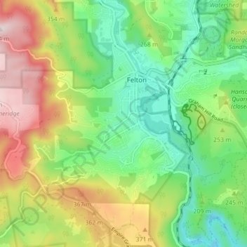
Name: Felton topographic map, elevation, terrain.
Location: Felton, Santa Cruz County, California, United States (37.02352 -122.10617 37.05955 -122.03730)
Average elevation: 218 m
Minimum elevation: 26 m
Maximum elevation: 531 m
Other topographic maps
Click on a map to view its topography, its elevation and its terrain.
Aptos
United States > California > Santa Cruz County > Seacliff
On March 16–20, 1905, the Leonard Ranch near La Selva was the site of experiments with a new tandem-wing glider designed and built by John J. Montgomery. Hoisted aloft by hot-air balloon to considerable heights, over a series of test flights pilot Daniel J. Maloney was able to demonstrate the control and…
Average elevation: 112 m
Mount Hermon
United States > California > Santa Cruz County > Felton > Mount Hermon
Average elevation: 154 m