
Lightning Ridge topographic map
Interactive map
Click on the map to display elevation.
About this map
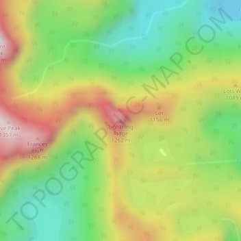
Name: Lightning Ridge topographic map, elevation, terrain.
Location: Lightning Ridge, Tasmanie, Australie (-42.95183 146.44302 -42.95173 146.44312)
Average elevation: 866 m
Minimum elevation: 496 m
Maximum elevation: 1,350 m
Other topographic maps
Click on a map to view its topography, its elevation and its terrain.
Deal Island
Deal Island, Flinders Council, Tasmanie, Australie
Average elevation: 45 m
Mount Mawson
Mount Mawson, Derwent Valley, Tasmanie, Australie
Average elevation: 1,063 m
Glamorgan-Spring Bay
Glamorgan-Spring Bay, Tasmanie, Australie
Average elevation: 201 m
Île Macquarie
Australie > Tasmanie > Macquarie Island Station
Île Macquarie, Macquarie Island Station, Huon Valley, Tasmanie, Australie
Average elevation: 20 m