
Hobart topographic map
Interactive map
Click on the map to display elevation.
About this map
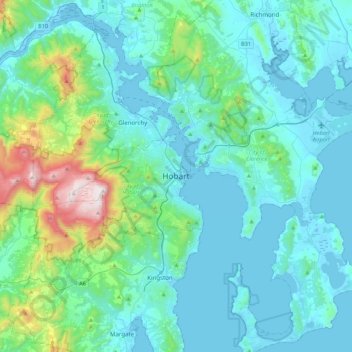
Name: Hobart topographic map, elevation, terrain.
Location: Hobart, City of Hobart, Tasmanie, 7000, Australie (-43.04251 147.16812 -42.72251 147.48812)
Average elevation: 179 m
Minimum elevation: -3 m
Maximum elevation: 1,260 m
Other topographic maps
Click on a map to view its topography, its elevation and its terrain.
Deal Island
Deal Island, Flinders Council, Tasmanie, Australie
Average elevation: 45 m
Mount Mawson
Mount Mawson, Derwent Valley, Tasmanie, Australie
Average elevation: 1,063 m
Glamorgan-Spring Bay
Glamorgan-Spring Bay, Tasmanie, Australie
Average elevation: 201 m
Île Macquarie
Australie > Tasmanie > Macquarie Island Station
Île Macquarie, Macquarie Island Station, Huon Valley, Tasmanie, Australie
Average elevation: 20 m