Geolocate

Colledimacine topographic map

Click on the map to display elevation.

About this map

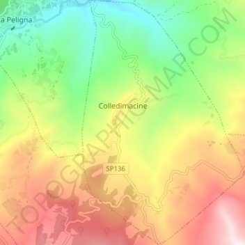
Name: Colledimacine topographic map, elevation, terrain.

Location: Colledimacine, Chieti, Abruzzo, Italy (41.97793 14.19011 42.02454 14.23178)

Average elevation: 729 m

Minimum elevation: 368 m

Maximum elevation: 1,159 m

Other topographic maps

Click on a map to view its topography, its elevation and its terrain.

Vallone di Santo Spirito

Italy > Abruzzo > Chieti > Fara San Martino

Average elevation: 1,273 m

Buonanotte

Italy > Abruzzo > Chieti > Vasto

Average elevation: 43 m

Fallascoso

Italy > Abruzzo > Chieti > Torricella Peligna

Average elevation: 839 m

Casali

Italy > Abruzzo > Chieti > Schiavi di Abruzzo

Average elevation: 734 m

Coderuto

Italy > Abruzzo > Chieti > Torrevecchia Teatina

Average elevation: 77 m

Foro

Italy > Abruzzo > Chieti > Miglianico

Average elevation: 143 m

Aquilano

Italy > Abruzzo > Chieti > Ortona > Aquilano

Average elevation: 86 m

Gear up for your next adventure:

🔋Solar Power Bank - Keep your GPS and devices charged during long outdoor trips
💧Filtered Water Bottle - Safe drinking water on the go
🔦LED Flashlight - Powerful and long-lasting flashlight for camping and emergencies
🔦UV Flashlight - Detect minerals or specific insects in the dark
🧢Sun Hat - Wide-brim hat for sun protection

As an Amazon Associate, this site earns from qualifying purchases at no extra cost to you.