Geolocate

Alamo Heights topographic map

Click on the map to display elevation.

About this map

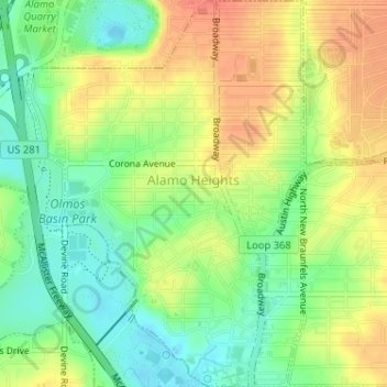
Name: Alamo Heights topographic map, elevation, terrain.

Location: Alamo Heights, Bexar County, Texas, United States (29.46821 -98.48217 29.49619 -98.45925)

Average elevation: 232 m

Minimum elevation: 208 m

Maximum elevation: 257 m

Other topographic maps

Click on a map to view its topography, its elevation and its terrain.

San Antonio

United States > Texas > Bexar County > San Antonio

Average elevation: 218 m

Sedona

United States > Texas > Bexar County > San Antonio

Average elevation: 301 m

Eldorado Lake

United States > Texas > Bexar County > San Antonio

Average elevation: 250 m

Mount Smith

United States > Texas > Bexar County

Average elevation: 515 m

Gear up for your next adventure:

🧢Hiking Sun Hat - Wide-brimmed protection for exposed mountain ridges
🔭Outdoor Binoculars - Lightweight binoculars for birdwatching and hiking
🧼Biodegradable Camp Soap - Environmentally friendly cleaning for gear and body
🥾Waterproof Hiking Boots - Essential footwear for rugged terrain and wet Canadian trails
🧢Beanie Hat - Keep your head warm in cold weather

As an Amazon Associate, this site earns from qualifying purchases at no extra cost to you.