Geolocate

Tavira topographic map

Interactive map

Click on the map to display elevation.

About this map

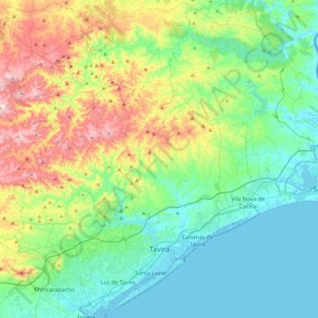
Name: Tavira topographic map, elevation, terrain.

Location: Tavira, Faro, Portugal (37.05439 -7.91518 37.38697 -7.56882)

Average elevation: 147 m

Minimum elevation: -1 m

Maximum elevation: 538 m

Other topographic maps

Click on a map to view its topography, its elevation and its terrain.

Lagos

Portugal > Faro

Average elevation: 57 m

Albufeira

Portugal > Faro

Average elevation: 77 m

Aroal

Portugal > Faro > Boliqueime

Average elevation: 114 m

Portimão

Portugal > Faro

The geographical distribution of the altitude and relief of the municipality of Portimão generically follow the three types of territory present in the Barlavento: the coastal region, the Barrocal (a region between the coastal region and the mountains) and the mountains up north. Each one with their own…

Average elevation: 67 m

Folga

Portugal > Faro

Average elevation: 249 m

Paderne

Portugal > Faro > Paderne > Paderne

Average elevation: 87 m

Faro

Portugal > Faro > Faro

Average elevation: 53 m