Geolocate

Sohna topographic map

Click on the map to display elevation.

About this map

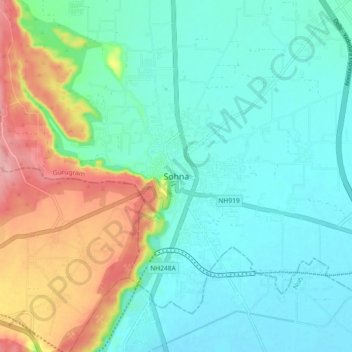
Name: Sohna topographic map, elevation, terrain.

Location: Sohna, Gurugram, Haryana, 122103, India (28.20599 77.02710 28.28599 77.10710)

Average elevation: 229 m

Minimum elevation: 193 m

Maximum elevation: 324 m

Other topographic maps

Click on a map to view its topography, its elevation and its terrain.

Gurugram

India > Haryana > Gurugram

Average elevation: 259 m

Sector 14

India > Haryana > Gurugram

Average elevation: 235 m

Sector 53

India > Haryana > Gurugram

Average elevation: 247 m

Sector 78

India > Haryana > Gurugram

Average elevation: 248 m

Sector 80

India > Haryana > Gurugram

Average elevation: 246 m

Karma Lakelands

India > Haryana > Gurugram

Average elevation: 247 m

Sector 58

India > Haryana > Gurugram

Average elevation: 246 m

Gurgaon One

India > Haryana > Gurugram

Average elevation: 228 m

Sector 6

India > Haryana > Gurugram

Average elevation: 222 m

Sector 112

India > Haryana > Gurugram

Average elevation: 214 m

Sector 30

India > Haryana > Gurugram

Average elevation: 232 m

Sector 4

India > Haryana > Gurugram

Average elevation: 219 m

Sector 42

India > Haryana > Gurugram

Average elevation: 264 m

Sikanderpur

India > Haryana > Gurugram

Average elevation: 251 m

Sector 24

India > Haryana > Gurugram

Average elevation: 249 m

Sector 32

India > Haryana > Gurugram

Average elevation: 228 m

Sector 67

India > Haryana > Gurugram

Average elevation: 229 m

Sohna

India > Haryana > Gurugram

Average elevation: 242 m

Gear up for your next adventure:

🧴Sunscreen SPF - Broad-spectrum sunscreen for outdoor activities
Camping Tent - Weather-resistant tents suitable for 2 to 6 people
🔪Outdoor Multitool - Versatile tool for repairs and food prep in the wild
🧢Sun Hat - Wide-brim hat for sun protection
🛶Canoe Life Vest - Safety vest for water sports

As an Amazon Associate, this site earns from qualifying purchases at no extra cost to you.