Geolocate

Tangru topographic map

Click on the map to display elevation.

About this map

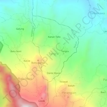
Name: Tangru topographic map, elevation, terrain.

Location: Tangru, Enrekang, South Sulawesi, Sulawesi, 91753, Indonesia (-3.45732 119.81866 -3.41732 119.85866)

Average elevation: 776 m

Minimum elevation: 459 m

Maximum elevation: 1,318 m

Other topographic maps

Click on a map to view its topography, its elevation and its terrain.

Baraka

Indonesia > South Sulawesi > Enrekang

Average elevation: 827 m

Malua

Indonesia > South Sulawesi > Enrekang

Average elevation: 709 m

Alla

Indonesia > South Sulawesi > Enrekang

Average elevation: 1,037 m

Bungin

Indonesia > South Sulawesi > Enrekang

Average elevation: 1,238 m

Cendana

Indonesia > South Sulawesi > Enrekang

Average elevation: 152 m

Maiwa

Indonesia > South Sulawesi > Enrekang

Average elevation: 214 m

Malua

Indonesia > South Sulawesi > Enrekang

Average elevation: 709 m

Buntu Batu

Indonesia > South Sulawesi > Enrekang

Average elevation: 1,459 m

Gear up for your next adventure:

🎒Fully Waterproof Backpack - Total protection for photography gear and electronics
🪑Insulated Seat Pad - Protect your seat from cold rocks and wet logs
🧼Biodegradable Camp Soap - Environmentally friendly cleaning for gear and body
🛏️Camping Sleeping Mat - Comfortable mats for sleeping outdoors
🥾Hiking Leggings - Comfortable leggings for outdoor activities

As an Amazon Associate, this site earns from qualifying purchases at no extra cost to you.