Geolocate

Dunbar topographic map

Click on the map to display elevation.

About this map

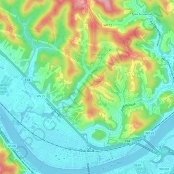
Name: Dunbar topographic map, elevation, terrain.

Location: Dunbar, Kanawha County, West Virginia, 25064, United States (38.35613 -81.75943 38.39487 -81.70746)

Average elevation: 221 m

Minimum elevation: 174 m

Maximum elevation: 322 m

Other topographic maps

Click on a map to view its topography, its elevation and its terrain.

Acme

United States > West Virginia > Kanawha County

Average elevation: 528 m

London

United States > West Virginia > Kanawha County

Average elevation: 317 m

United

United States > West Virginia > Kanawha County

Average elevation: 607 m

Gear up for your next adventure:

🎒Fully Waterproof Backpack - Total protection for photography gear and electronics
🥾All-Terrain Hiking Boots - Versatile boots for varied hiking conditions
🥾Approach Shoes - Shoes designed for climbing approaches and rugged trails
🧴Sunscreen SPF - Broad-spectrum sunscreen for outdoor activities
🥾Light Hiking Boots - Lightweight and comfortable boots for day hikes

As an Amazon Associate, this site earns from qualifying purchases at no extra cost to you.