Geolocate

Acme topographic map

Click on the map to display elevation.

About this map

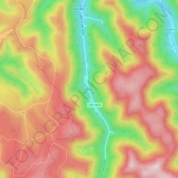
Name: Acme topographic map, elevation, terrain.

Location: Acme, Kanawha County, West Virginia, United States (38.01677 -81.47567 38.05677 -81.43567)

Average elevation: 528 m

Minimum elevation: 285 m

Maximum elevation: 713 m

Other topographic maps

Click on a map to view its topography, its elevation and its terrain.

Dunbar

United States > West Virginia > Kanawha County

Average elevation: 221 m

Gear up for your next adventure:

🧴Sunscreen SPF - Broad-spectrum sunscreen for outdoor activities
💡Compact LED Flashlight - Powerful and portable flashlight for outdoor use
🧣Evaporative Cooling Towel - Beat the heat during intense summer climbs
🧼Biodegradable Camp Soap - Environmentally friendly cleaning for gear and body
🧭GPS Handheld Device - Reliable GPS navigation for outdoor adventures

As an Amazon Associate, this site earns from qualifying purchases at no extra cost to you.