
Val-Joli topographic map
Interactive map
Click on the map to display elevation.
About this map
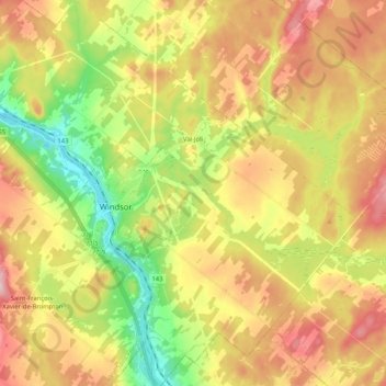
Name: Val-Joli topographic map, elevation, terrain.
Location: Val-Joli, Le Val-Saint-François, Estrie, Quebec, Canada (45.50199 -72.06914 45.64748 -71.87297)
Average elevation: 220 m
Minimum elevation: 116 m
Maximum elevation: 329 m
Other topographic maps
Click on a map to view its topography, its elevation and its terrain.
Sainte-Anne-de-la-Rochelle
Canada > Quebec > Le Val-Saint-François
Sainte-Anne-de-la-Rochelle, Le Val-Saint-François, Estrie, Quebec, Canada
Average elevation: 252 m
McCourts Corner
Canada > Quebec > Le Val-Saint-François > Val-Joli
McCourts Corner, Val-Joli, Le Val-Saint-François, Estrie, Quebec, J1S 2E1, Canada
Average elevation: 179 m
Richmond
Canada > Quebec > Le Val-Saint-François > Ville de Richmond > Richmond
Richmond, Ville de Richmond, Le Val-Saint-François, Estrie, Quebec, J0B 2H0, Canada
Average elevation: 189 m
Valcourt (ville)
Canada > Quebec > Le Val-Saint-François > Valcourt (ville)
Valcourt (ville), Le Val-Saint-François, Estrie, Quebec, J0E 2L0, Canada
Average elevation: 215 m
Saint-Claude
Canada > Quebec > Le Val-Saint-François
Saint-Claude, Le Val-Saint-François, Estrie, Quebec, Canada
Average elevation: 233 m