
Make a donation
Gear up for your next adventure:
As an Amazon Associate, this site earns from qualifying purchases at no extra cost to you.
Walchsing topographic map
Click on the map to display elevation.
Make a donation
Gear up for your next adventure:
As an Amazon Associate, this site earns from qualifying purchases at no extra cost to you.
About this map
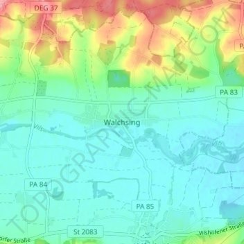
Name: Walchsing topographic map, elevation, terrain.
Average elevation: 340 m
Minimum elevation: 314 m
Maximum elevation: 411 m
Make a donation
Gear up for your next adventure:
As an Amazon Associate, this site earns from qualifying purchases at no extra cost to you.
Other topographic maps
Click on a map to view its topography, its elevation and its terrain.
Wegscheid
Deutschland > Bayern > Landkreis Passau
Der Markt in etwa 720 Metern Höhe am Osthang des Ponzaun-Berges bietet als typische Höhensiedlung eine weite Rundsicht.
Average elevation: 692 m
Hauzenberg
Deutschland > Bayern > Landkreis Passau
Das Klima in der Stadt-Gemeinde unterscheidet sich – bedingt durch große Höhenunterschiede – erheblich. Während der Hauptort 546 m (Pfarrkirche St. Vitus) hoch liegt, befindet sich die ehemalige Bahnstation Kaindlmühle nur 350 m hoch. Der Ortsteil Bauzing – die höchstgelegene größere Siedlung des…
Average elevation: 581 m
Sonnen
Deutschland > Bayern > Landkreis Passau
Sonnen liegt in der Region Donau-Wald im unteren Bayerischen Wald und ist die höchstgelegene Gemeinde im Landkreis Passau auf einer Höhe von 700 bis 900 Metern. Nach Passau sind es 28 km, nach Hauzenberg 9 km und Waldkirchen bzw. Wegscheid jeweils 13 km. Die Grenze zu Oberösterreich liegt nur 8 km entfernt.
Average elevation: 779 m
Make a donation
Gear up for your next adventure:
As an Amazon Associate, this site earns from qualifying purchases at no extra cost to you.
Fürstenzell
Deutschland > Bayern > Landkreis Passau
Im Rahmen der Gebietsreform wurden am 1. Januar 1972 die Gemeinden Altenmarkt und Bad Höhenstadt sowie Teile der Gemeinde Engertsham eingegliedert. Im Jahre 1978 folgten der größte Teil der Gemeinde Voglarn und Teile der Gemeinde Sandbach.
Average elevation: 389 m