
Make a donation
Gear up for your next adventure:
As an Amazon Associate, this site earns from qualifying purchases at no extra cost to you.
Hauzenberg topographic map
Click on the map to display elevation.
Make a donation
Gear up for your next adventure:
As an Amazon Associate, this site earns from qualifying purchases at no extra cost to you.
Hauzenberg
Das Klima in der Stadt-Gemeinde unterscheidet sich – bedingt durch große Höhenunterschiede – erheblich. Während der Hauptort 546 m (Pfarrkirche St. Vitus) hoch liegt, befindet sich die ehemalige Bahnstation Kaindlmühle nur 350 m hoch. Der Ortsteil Bauzing – die höchstgelegene größere Siedlung des Landkreises Passau – liegt aber 800 Meter hoch. Besonders eindrucksvoll sind diese Unterschiede im Frühling auszumachen. Die Vegetation entwickelt sich im Tal ein bis zwei Wochen früher als in den Hochlagen.
Make a donation
Gear up for your next adventure:
As an Amazon Associate, this site earns from qualifying purchases at no extra cost to you.
About this map
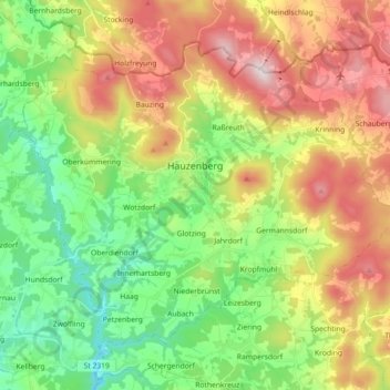
Name: Hauzenberg topographic map, elevation, terrain.
Location: Hauzenberg, Landkreis Passau, Bayern, 94051, Deutschland (48.59920 13.54159 48.69297 13.72162)
Average elevation: 581 m
Minimum elevation: 332 m
Maximum elevation: 948 m
Make a donation
Gear up for your next adventure:
As an Amazon Associate, this site earns from qualifying purchases at no extra cost to you.
Other topographic maps
Click on a map to view its topography, its elevation and its terrain.
Make a donation
Gear up for your next adventure:
As an Amazon Associate, this site earns from qualifying purchases at no extra cost to you.