
Make a donation
Gear up for your next adventure:
As an Amazon Associate, this site earns from qualifying purchases at no extra cost to you.
Sonnen topographic map
Click on the map to display elevation.
Make a donation
Gear up for your next adventure:
As an Amazon Associate, this site earns from qualifying purchases at no extra cost to you.
Sonnen
Sonnen liegt in der Region Donau-Wald im unteren Bayerischen Wald und ist die höchstgelegene Gemeinde im Landkreis Passau auf einer Höhe von 700 bis 900 Metern. Nach Passau sind es 28 km, nach Hauzenberg 9 km und Waldkirchen bzw. Wegscheid jeweils 13 km. Die Grenze zu Oberösterreich liegt nur 8 km entfernt.
Make a donation
Gear up for your next adventure:
As an Amazon Associate, this site earns from qualifying purchases at no extra cost to you.
About this map
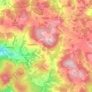
Name: Sonnen topographic map, elevation, terrain.
Location: Sonnen, Landkreis Passau, Bayern, 94164, Deutschland (48.64211 13.67590 48.69217 13.75993)
Average elevation: 779 m
Minimum elevation: 580 m
Maximum elevation: 895 m
Make a donation
Gear up for your next adventure:
As an Amazon Associate, this site earns from qualifying purchases at no extra cost to you.
Other topographic maps
Click on a map to view its topography, its elevation and its terrain.
Make a donation
Gear up for your next adventure:
As an Amazon Associate, this site earns from qualifying purchases at no extra cost to you.