
Rhodes topographic map
Interactive map
Click on the map to display elevation.
About this map
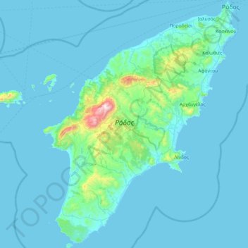
Name: Rhodes topographic map, elevation, terrain.
Location: Rhodes, Aegean, Greece (35.87666 27.68357 36.45828 28.24763)
Average elevation: 67 m
Minimum elevation: 0 m
Maximum elevation: 1,200 m
The Rhodian population of fallow deer was found to be genetically distinct in 2005, and to be of urgent conservation concern. In Petaloudes Valley (Greek for "Valley of the Butterflies"), large numbers of tiger moths gather during the summer months. Mount Attavyros, at 1,216 metres (3,990 ft), is the island's highest point of elevation.
Other topographic maps
Click on a map to view its topography, its elevation and its terrain.
Kea
Greece > Aegean > Kea-Kythnos Regional Unit
Kea, Kea-Kythnos Regional Unit, South Aegean, Aegean, 840 02, Greece
Average elevation: 81 m
Ios
Greece > Aegean > Thira Regional Unit
Ios, Thira Regional Unit, South Aegean, Aegean, 840 01, Greece
Average elevation: 73 m
Embonas
Greece > Aegean > Rhodes Regional Unit
Embonas, Municipality of Rhodes, Rhodes Regional Unit, South Aegean, Aegean, 851 08, Greece
Average elevation: 508 m
Lindos
Greece > Aegean > Rhodes Regional Unit
Lindos, Municipality of Rhodes, Rhodes Regional Unit, South Aegean, Aegean, 851 07, Greece
Average elevation: 47 m
Μαριτσά
Greece > Aegean > Rhodes Regional Unit
Μαριτσά, Municipality of Rhodes, Rhodes Regional Unit, South Aegean, Aegean, 851 06, Greece
Average elevation: 165 m
Municipal Unit of Rhodes
Greece > Aegean > Rhodes Regional Unit
Municipal Unit of Rhodes, Municipality of Rhodes, Rhodes Regional Unit, South Aegean, Aegean, Greece
Average elevation: 27 m
Salakos
Greece > Aegean > Rhodes Regional Unit
Salakos, Municipality of Rhodes, Rhodes Regional Unit, South Aegean, Aegean, 851 06, Greece
Average elevation: 287 m
Milos
Greece > Aegean > Milos Regional Unit
Milos, Milos Regional Unit, South Aegean, Aegean, Greece
Average elevation: 24 m
Pei
Greece > Aegean > Karpathos Regional Unit > Pei
Pei, Municipality of Karpathos, Karpathos Regional Unit, South Aegean, Aegean, Greece
Average elevation: 135 m
Kos
Greece > Aegean > Kos Regional Unit
Kos, Kos Regional Unit, South Aegean, Aegean, Greece
Average elevation: 25 m
Kiotari
Greece > Aegean > Rhodes Regional Unit > Kiotari
Kiotari, Municipality of Rhodes, Rhodes Regional Unit, South Aegean, Aegean, 851 09, Greece
Average elevation: 33 m
Municipality of Mykonos
Greece > Aegean > Mykonos Regional Unit
Municipality of Mykonos, Mykonos Regional Unit, South Aegean, Aegean, Greece
Average elevation: 11 m
Mykonos
Greece > Aegean > Mykonos Regional Unit > Platys Gialos
Mykonos, Platys Gialos, Municipality of Mykonos, Mykonos Regional Unit, South Aegean, Aegean, 846 00, Greece
Average elevation: 38 m
Santorini
Greece > Aegean > Thira Regional Unit > Thira Municipal Unit
Santorini, Thira Municipal Unit, Municipality of Thira, Thira Regional Unit, South Aegean, Aegean, Greece
Average elevation: 30 m
Panteli
Greece > Aegean > Vromolithos
Panteli, Vromolithos, Δήμος Λέρου, Kalmynos Regional Unit, South Aegean Region, Aegean, 854 00, Greece
Average elevation: 33 m
Notio Aspronisi West
Notio Aspronisi West, Δήμος Λειψών, Kalmynos Regional Unit, South Aegean, Aegean, Greece
Average elevation: 2 m
Chios
Greece > Aegean > Chios Regional Unit
Chios, Chios Regional Unit, Northern Aegean, Aegean, Greece
Average elevation: 99 m
Thira Municipal Unit
Greece > Aegean > Thira Municipal Unit
Thira Municipal Unit, Δήμος Θήρας, Thira Regional Unit, South Aegean Region, Aegean, Greece
Average elevation: 12 m