
Μαριτσά topographic map
Interactive map
Click on the map to display elevation.
About this map
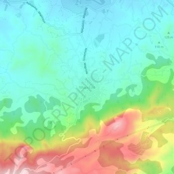
Name: Μαριτσά topographic map, elevation, terrain.
Average elevation: 165 m
Minimum elevation: 50 m
Maximum elevation: 426 m
Other topographic maps
Click on a map to view its topography, its elevation and its terrain.
Embonas
Greece > Aegean > Rhodes Regional Unit
Embonas, Municipality of Rhodes, Rhodes Regional Unit, South Aegean, Aegean, 851 08, Greece
Average elevation: 508 m
Lindos
Greece > Aegean > Rhodes Regional Unit
Lindos, Municipality of Rhodes, Rhodes Regional Unit, South Aegean, Aegean, 851 07, Greece
Average elevation: 47 m
Municipal Unit of Rhodes
Greece > Aegean > Rhodes Regional Unit
Municipal Unit of Rhodes, Municipality of Rhodes, Rhodes Regional Unit, South Aegean, Aegean, Greece
Average elevation: 27 m
Salakos
Greece > Aegean > Rhodes Regional Unit
Salakos, Municipality of Rhodes, Rhodes Regional Unit, South Aegean, Aegean, 851 06, Greece
Average elevation: 287 m
Kiotari
Greece > Aegean > Rhodes Regional Unit > Kiotari
Kiotari, Municipality of Rhodes, Rhodes Regional Unit, South Aegean, Aegean, 851 09, Greece
Average elevation: 33 m