
Ios topographic map
Click on the map to display elevation.
Ios
The highest elevation (723 m, 2372 ft) is the Kastro (Greek: Κάστρο) peak also called Pyrgos (Greek: Πύργος), located in the center of the island, while around the Kastro are the next three Highest peaks: Xylodema (Greek: Ξυλόδεμα) (660 m, 2165 ft), Kostiza (Greek: Κοστίζα) (586 m, 1923 ft) and Prophetis Elias (Greek: Προφήτης Ηλίας) (490 m, 951 ft).
About this map
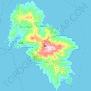
Name: Ios topographic map, elevation, terrain.
Location: Ios, Thira Regional Unit, South Aegean, Aegean, 840 01, Greece (36.64210 25.24594 36.79256 25.40308)
Average elevation: 73 m
Minimum elevation: 0 m
Maximum elevation: 717 m