
Meslan topographic map
Click on the map to display elevation.
Meslan
La commune est vallonnée et son territoire s'étage entre 35 m (fond de la vallée de l'Ellé à l'extrémité sud de la commune) et 160 m d'altitude (près du village de Restinois à l'extrémité nord de la commune). En plus de l'Ellé qui la borde à l'ouest, la commune est parcourue par de nombreux cours d'eau de taille plus modeste : le ruisseau de la Noguette, long de 6,2 km, qui se jette dans l'Ellé après avoir matérialisé la limite sud de la commune, le Stang Hingant, qui traverse la commune d'est en ouest avant de se jeter dans l'Aër à Pont-Tanguy, le ruisseau de Kerloas, long de 6,7 km, qui se jette dans le Scorff et le ruisseau du Moulin Julien, long de 3,1 km, qui se jette dans l'Ellé au pont de Loge-Coucou. Ces cours d'eau appartiennent tous au bassin de l'Ellé/Laïta à l'exception du ruisseau de Kerloas qui appartient au bassin du Scorff.
About this map
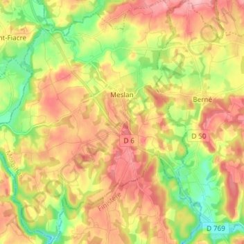
Name: Meslan topographic map, elevation, terrain.
Average elevation: 105 m
Minimum elevation: 37 m
Maximum elevation: 169 m
Other topographic maps
Click on a map to view its topography, its elevation and its terrain.
Île de Berder
France > Bretagne > Morbihan > Larmor-Baden
Longue d'environ 1 200 m du nord au sud et large de 300 m au maximum, l'île culmine dans sa partie centrale à 13 m d'altitude.
Average elevation: 1 m
Quily
France > Bretagne > Morbihan > Val d'Oust
Le finage de l'ancienne commune de Quily est constitué pour l'essentiel d'un plateau bosselé qui culmine à l'extrême ouest de son territoire à 135 mètres d'altitude et dont la pente décroit en direction de l'est jusque vers 70 mètres d'altitude. Ce plateau est limité par un escarpement d'une…
Average elevation: 71 m
Plage de Kerpape
France > Bretagne > Morbihan > Plœmeur > Pen Palud
La partie intérieure de la commune est constituée pour l'essentiel d'un plateau qui ne dépasse qu'à peine 50 mètres d'altitude, le terril de la carrière de kaolin de Kergantic étant le sommet le plus visible de loin.
Average elevation: 5 m