
Pen Palud topographic map
Click on the map to display elevation.
About this map
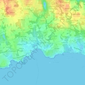
Name: Pen Palud topographic map, elevation, terrain.
Average elevation: 13 m
Minimum elevation: -1 m
Maximum elevation: 41 m
Other topographic maps
Click on a map to view its topography, its elevation and its terrain.
Plage de Kerpape
France > Bretagne > Morbihan > Plœmeur > Pen Palud
La partie intérieure de la commune est constituée pour l'essentiel d'un plateau qui ne dépasse qu'à peine 50 mètres d'altitude, le terril de la carrière de kaolin de Kergantic étant le sommet le plus visible de loin.
Average elevation: 5 m
Saint-Adrien
France > Bretagne > Morbihan > Plœmeur > Le Fort-Bloqué > Saint-Adrien
Average elevation: 10 m
Pointe du Castel
France > Bretagne > Morbihan > Plœmeur > Le Courégant > Kerguen
Average elevation: 6 m