Geolocate

Sadat City topographic map

Click on the map to display elevation.

About this map

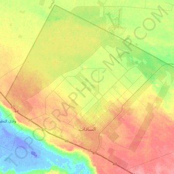
Name: Sadat City topographic map, elevation, terrain.

Location: Sadat City, Al Minufiya, Egypt (30.29963 30.35471 30.56448 30.67887)

Average elevation: 31 m

Minimum elevation: -27 m

Maximum elevation: 67 m

Other topographic maps

Click on a map to view its topography, its elevation and its terrain.

Tala

Egypt > Al Minufiya

Average elevation: 10 m

Shamma

Egypt > Al Minufiya

Average elevation: 13 m

Kafr Al-Gazar

Egypt > Al Minufiya

Average elevation: 14 m

Quwaysina

Egypt > Al Minufiya

Average elevation: 12 m

Sadat

Egypt > Al Minufiya

Average elevation: 38 m

Gear up for your next adventure:

💡Portable Camping Lamp - Rechargeable lamp for campsite lighting
🦌Outdoor Trail Camera - Monitor wildlife activity near your favorite spots
👖Convertible Hiking Pants - Zip-off legs to adapt to changing weather conditions
🥾Waterproof Hiking Boots - Essential footwear for rugged terrain and wet Canadian trails
🥘Camping Cookware Set - Compact nesting pots and pans for trail cooking

As an Amazon Associate, this site earns from qualifying purchases at no extra cost to you.