Geolocate

Quwaysina topographic map

Click on the map to display elevation.

About this map

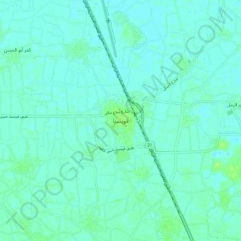
Name: Quwaysina topographic map, elevation, terrain.

Location: Quwaysina, Al Minufiya, 32631, Egypt (30.50566 31.09430 30.58566 31.17430)

Average elevation: 12 m

Minimum elevation: 9 m

Maximum elevation: 20 m

Other topographic maps

Click on a map to view its topography, its elevation and its terrain.

Sadat City

Egypt > Al Minufiya

Average elevation: 31 m

Sadat City

Egypt > Al Minufiya

Average elevation: 31 m

Kafr Al Bagour Village

Egypt > Al Minufiya

Average elevation: 14 m

Gear up for your next adventure:

🎒Hiking Backpack - Lightweight and ergonomic backpacks for day hikes or multi-day treks
🔭Outdoor Binoculars - Lightweight binoculars for birdwatching and hiking
🧦Merino Wool Socks - Moisture-wicking comfort for long-distance hiking
🔦LED Flashlight - Powerful and long-lasting flashlight for camping and emergencies
🔦LED Headtorch - Bright and durable light for night activities

As an Amazon Associate, this site earns from qualifying purchases at no extra cost to you.