Geolocate

Tapong topographic map

Click on the map to display elevation.

About this map

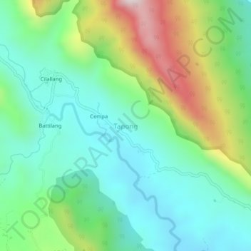
Name: Tapong topographic map, elevation, terrain.

Location: Tapong, Enrekang, South Sulawesi, Sulawesi, Indonesia (-3.68114 119.87344 -3.64114 119.91344)

Average elevation: 335 m

Minimum elevation: 90 m

Maximum elevation: 898 m

Other topographic maps

Click on a map to view its topography, its elevation and its terrain.

Baraka

Indonesia > South Sulawesi > Enrekang

Average elevation: 827 m

Bungin

Indonesia > South Sulawesi > Enrekang

Average elevation: 1,238 m

Malua

Indonesia > South Sulawesi > Enrekang

Average elevation: 709 m

Buntu Batu

Indonesia > South Sulawesi > Enrekang

Average elevation: 1,459 m

Cendana

Indonesia > South Sulawesi > Enrekang

Average elevation: 152 m

Maiwa

Indonesia > South Sulawesi > Enrekang

Average elevation: 214 m

Malua

Indonesia > South Sulawesi > Enrekang

Average elevation: 709 m

Alla

Indonesia > South Sulawesi > Enrekang

Average elevation: 1,037 m

Gear up for your next adventure:

🕯️Camping Lantern - Illuminates your entire campsite with high-efficiency LEDs
🔋Lithium AA Batteries - Long-lasting power that performs in extreme cold
Tent Footprint - Protect tent floor and increase durability
🛌Down Sleeping Bag - Superior warmth-to-weight ratio for cold nights
💧Hydration Bladder - Hands-free hydration solution for long treks

As an Amazon Associate, this site earns from qualifying purchases at no extra cost to you.