Geolocate

Fossa topographic map

Click on the map to display elevation.

About this map

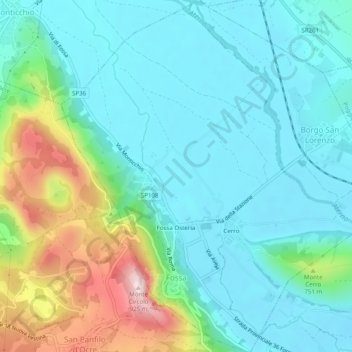
Name: Fossa topographic map, elevation, terrain.

Location: Fossa, L'Aquila, Abruzzo, Italy (42.28512 13.47194 42.32166 13.51883)

Average elevation: 649 m

Minimum elevation: 560 m

Maximum elevation: 931 m

Other topographic maps

Click on a map to view its topography, its elevation and its terrain.

Castrovalva

Italy > Abruzzo > L'Aquila > Anversa degli Abruzzi

Average elevation: 994 m

Poggio Cinolfo

Italy > Abruzzo > L'Aquila > Carsoli

Average elevation: 649 m

Forme

Italy > Abruzzo > L'Aquila

Average elevation: 1,224 m

Lucoli Alto

Italy > Abruzzo > L'Aquila > Collimento

Average elevation: 1,224 m

Campo Imperatore

Italy > Abruzzo > L'Aquila > L'Aquila

The plateau's altitude ranges from 1,500 to 1,900 meters. It covers an expanse of approximately 80 km². Campo Imperatore is home to one of Italy's oldest alpine ski resorts. Located on the plateau's western edge, the resort began commercial operation in the 1920s and continues to thrive as a ski resort to…

Average elevation: 2,056 m

Fonte Cerreto

Italy > Abruzzo > L'Aquila > L'Aquila

Average elevation: 1,329 m

Assergi

Italy > Abruzzo > L'Aquila > L'Aquila

Assergi is a frazione of the comune of L'Aquila, located about 11 km (6.8 mi) from the capital. With a population of just over 500, it is situated at an altitude of approximately 1,000 meters, below the western slope of the Gran Sasso in a small plain called the Piana di Assergi (Plain of Assergi). Assergi was…

Average elevation: 1,035 m

Ponte San Giovanni

Italy > Abruzzo > L'Aquila > Civitatomassa

Average elevation: 729 m

Marana

Italy > Abruzzo > L'Aquila

Average elevation: 932 m

Bominaco

Italy > Abruzzo > L'Aquila

Average elevation: 962 m

Aragno

Italy > Abruzzo > L'Aquila > L'Aquila

Average elevation: 1,072 m

Casale d'Abruzzo

Italy > Abruzzo > L'Aquila > Marana

Average elevation: 933 m

San Nicandro

Italy > Abruzzo > L'Aquila

Average elevation: 806 m

Marsia

Italy > Abruzzo > L'Aquila > Tagliacozzo

Average elevation: 1,391 m

Gear up for your next adventure:

🥾Waterproof Hiking Shoes - Durable shoes for wet and rugged trails
🥾Approach Boots - Comfortable boots for hiking and climbing approaches
🥾Waterproof Hiking Boots - Boots keeping your feet dry in wet conditions
Family Camping Tent - Spacious tent suitable for family camping trips
Camping Coffee Maker - Brew fresh coffee anywhere on the topographic map

As an Amazon Associate, this site earns from qualifying purchases at no extra cost to you.