Geolocate

Clem topographic map

Click on the map to display elevation.

About this map

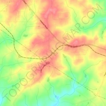
Name: Clem topographic map, elevation, terrain.

Location: Clem, Carroll County, Georgia, United States (33.50817 -85.03328 33.54817 -84.99328)

Average elevation: 337 m

Minimum elevation: 284 m

Maximum elevation: 375 m

Other topographic maps

Click on a map to view its topography, its elevation and its terrain.

Mount Zion

United States > Georgia > Carroll County

Average elevation: 356 m

Roopville

United States > Georgia > Carroll County

Average elevation: 350 m

Temple

United States > Georgia > Carroll County

Average elevation: 346 m

Roopville

United States > Georgia > Carroll County

Average elevation: 350 m

Gear up for your next adventure:

🦶Hiking Shoe Insoles - Added support for high arches and long days on feet
👟Sport Hiking Sandals - Breathable footwear for water crossings and camp rest
🎒Hiking Daypack - Lightweight and durable backpacks for day trips and excursions
🥾Trail Hiking Socks - Comfortable socks to prevent blisters and fatigue
🛰️Satellite Messenger - Emergency communication for areas with no cell service

As an Amazon Associate, this site earns from qualifying purchases at no extra cost to you.