Geolocate

Piendamó topographic map

Click on the map to display elevation.

Piendamó

The municipality is located in the Cauca Basin in the valley of the Cauca River at an altitude of 1,685 metres (5,528 ft) above mean sea level. It borders Silvia in the east, Morales in the west, Caldono in the north and Cajibio in the south.

Wikipedia (CC-BY-SA 3.0)

About this map

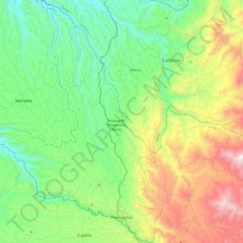
Name: Piendamó topographic map, elevation, terrain.

Location: Piendamó, Centro, Cauca, RAP Pacífico, 190530, Colombia (2.61481 -76.66891 2.85578 -76.49182)

Average elevation: 1,845 m

Minimum elevation: 1,263 m

Maximum elevation: 3,014 m

Other topographic maps

Click on a map to view its topography, its elevation and its terrain.

Coconuco

Colombia > Cauca > Puracé

Average elevation: 2,721 m

Las Botas

Colombia > Cauca > El Tambo

Average elevation: 1,729 m

Chamon

Colombia > Cauca > Guapi

Average elevation: 2 m

Lopez

Colombia > Cauca > Toribío

Average elevation: 3,087 m

Chisquio

Colombia > Cauca > El Tambo

Average elevation: 1,772 m

Loma Grande

Colombia > Cauca > San Sebastián

Average elevation: 2,130 m

Munchique

Colombia > Cauca > El Tambo > Boca del monte

Average elevation: 2,621 m

Galíndez

Colombia > Cauca

Average elevation: 594 m

Puracé

Colombia > Cauca > Puracé > Puracé

Average elevation: 2,678 m

Gear up for your next adventure:

🧭GPS Tracker - Track your location in remote areas safely
🧥Packable Rain Jacket - Breathable waterproof layer for unpredictable weather
🏃Hydration Running Vest - Carry water and maps close to your body for speed
🛶Kayak Dry Bag - Waterproof storage for kayaking adventures
🧤Rechargeable Heated Gloves - Extreme warmth for Canadian winter expeditions

As an Amazon Associate, this site earns from qualifying purchases at no extra cost to you.