
Make a donation
Gear up for your next adventure:
As an Amazon Associate, this site earns from qualifying purchases at no extra cost to you.
Tangermünde topographic map
Click on the map to display elevation.
Make a donation
Gear up for your next adventure:
As an Amazon Associate, this site earns from qualifying purchases at no extra cost to you.
Tangermünde
Aland | Altmärkische Höhe | Altmärkische Wische | Eichstedt (Altmark) | Goldbeck | Hassel | Hohenberg-Krusemark | Iden | Kamern | Klietz | Rochau | Schollene | Schönhausen (Elbe) | Wust-Fischbeck | Zehrental
Make a donation
Gear up for your next adventure:
As an Amazon Associate, this site earns from qualifying purchases at no extra cost to you.
About this map
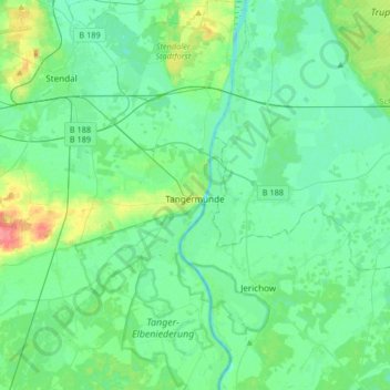
Name: Tangermünde topographic map, elevation, terrain.
Location: Tangermünde, Stendal, Sachsen-Anhalt, 39590, Deutschland (52.44475 11.87438 52.64482 12.01553)
Average elevation: 37 m
Minimum elevation: 24 m
Maximum elevation: 84 m
Make a donation
Gear up for your next adventure:
As an Amazon Associate, this site earns from qualifying purchases at no extra cost to you.
Other topographic maps
Click on a map to view its topography, its elevation and its terrain.
Gutshaus Hohenwulsch
Deutschland > Sachsen-Anhalt > Stendal > Bismark (Altmark) > Hohenwulsch
Average elevation: 55 m
Make a donation
Gear up for your next adventure:
As an Amazon Associate, this site earns from qualifying purchases at no extra cost to you.
Schnöggersburg (Wüstung)
Deutschland > Sachsen-Anhalt > Stendal > Stendal > Staats
Average elevation: 100 m
Make a donation
Gear up for your next adventure:
As an Amazon Associate, this site earns from qualifying purchases at no extra cost to you.
Make a donation
Gear up for your next adventure:
As an Amazon Associate, this site earns from qualifying purchases at no extra cost to you.