
Make a donation
Gear up for your next adventure:
As an Amazon Associate, this site earns from qualifying purchases at no extra cost to you.
Bockelberg topographic map
Click on the map to display elevation.
Make a donation
Gear up for your next adventure:
As an Amazon Associate, this site earns from qualifying purchases at no extra cost to you.
About this map
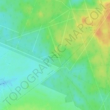
Name: Bockelberg topographic map, elevation, terrain.
Location: Bockelberg, Stendal, Sachsen-Anhalt, Deutschland (52.49588 11.63110 52.49598 11.63120)
Average elevation: 106 m
Minimum elevation: 92 m
Maximum elevation: 127 m
Make a donation
Gear up for your next adventure:
As an Amazon Associate, this site earns from qualifying purchases at no extra cost to you.
Other topographic maps
Click on a map to view its topography, its elevation and its terrain.
Insel
Deutschland > Sachsen-Anhalt > Stendal > Stendal
Insel, ein Dorf mit Kirche, liegt etwa 10 km von Stendal entfernt in der Altmark. Das Gelände fällt vom Tangermünder-Buchholzer Höhenzug in Richtung Norden zur Uchteniederung ab. Nördlich von Insel liegt die ehemalige Kiesgrube Hillberg.
Average elevation: 44 m
Dahlen
Deutschland > Sachsen-Anhalt > Stendal > Stendal
Die Umgebung wird vom Uchtetal im Norden und dem Tangermünder-Buchholzer Höhenzug bestimmt, der das Tal um bis zu 50 Meter überragt.
Average elevation: 46 m
Make a donation
Gear up for your next adventure:
As an Amazon Associate, this site earns from qualifying purchases at no extra cost to you.
Make a donation
Gear up for your next adventure:
As an Amazon Associate, this site earns from qualifying purchases at no extra cost to you.