Geolocate

New Moonta topographic map

Click on the map to display elevation.

About this map

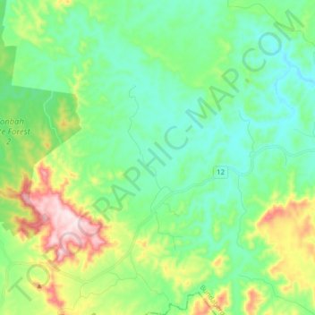
Name: New Moonta topographic map, elevation, terrain.

Location: New Moonta, Bundaberg Region, Queensland, 4671, Australia (-25.08394 151.67809 -24.94421 151.77809)

Average elevation: 185 m

Minimum elevation: 73 m

Maximum elevation: 479 m

Other topographic maps

Click on a map to view its topography, its elevation and its terrain.

Bundaberg

Australia > Queensland > Bundaberg Region

Average elevation: 18 m

Bundaberg

Australia > Queensland > Bundaberg Region

Average elevation: 18 m

Bundaberg

Australia > Queensland > Bundaberg Region

Average elevation: 18 m

Gin Gin

Australia > Queensland > Bundaberg Region > Gin Gin

Average elevation: 73 m

Burrum River

Australia > Queensland > Bundaberg Region > Buxton

Average elevation: 20 m

Isis River

Australia > Queensland > Bundaberg Region > Buxton

Average elevation: 12 m

Gear up for your next adventure:

🔋Lithium AA Batteries - Long-lasting power that performs in extreme cold
🧥Waterproof Jacket - Lightweight rain jackets for hiking and outdoor activities
🔦UV Flashlight - Detect minerals or specific insects in the dark
🔪Outdoor Multitool - Versatile tool for repairs and food prep in the wild
🧦Hiking Liner Socks - Thin base layer to prevent friction and blisters

As an Amazon Associate, this site earns from qualifying purchases at no extra cost to you.