Geolocate

Luyando topographic map

Click on the map to display elevation.

About this map

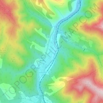
Name: Luyando topographic map, elevation, terrain.

Location: Luyando, Ayala, Álava, País Vasco, 01408, España (43.08200 -3.01950 43.11876 -2.97269)

Average elevation: 321 m

Minimum elevation: 145 m

Maximum elevation: 596 m

Other topographic maps

Click on a map to view its topography, its elevation and its terrain.

Respaldiza

España > País Vasco > Ayala

Average elevation: 318 m

Erbi

España > País Vasco > Ayala

Average elevation: 402 m

Etxaurren

España > País Vasco > Ayala > Menoio

Average elevation: 442 m

Artómaña

España > País Vasco > Ayala > Amurrio

Average elevation: 418 m

Gear up for your next adventure:

🔋Solar Power Bank - Keep your GPS and devices charged during long outdoor trips
🧢Hiking Hat - Sun-protective and breathable hats for long treks
🧊Insulated Water Bottle - Keeps drinks cold in summer and prevents freezing in winter
🚑Survival Whistle - Signal for help across long distances in mountains
🥾Waterproof Hiking Shoes - Durable shoes for wet and rugged trails

As an Amazon Associate, this site earns from qualifying purchases at no extra cost to you.