Geolocate

Arapuni topographic map

Click on the map to display elevation.

About this map

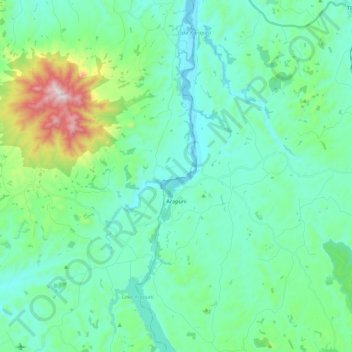
Name: Arapuni topographic map, elevation, terrain.

Location: Arapuni, South Waikato District, Waikato, New Zealand (-38.14646 175.62628 -37.97292 175.73161)

Average elevation: 194 m

Minimum elevation: 55 m

Maximum elevation: 778 m

Other topographic maps

Click on a map to view its topography, its elevation and its terrain.

Kinleith

New Zealand > Waikato > South Waikato District

Average elevation: 399 m

Tīrau

New Zealand > Waikato > South Waikato District > Arapuni

Average elevation: 194 m

Pakuranga

New Zealand > Waikato > South Waikato District

Average elevation: 298 m

Okoroire

New Zealand > Waikato > South Waikato District

Average elevation: 95 m

Lichfield

New Zealand > Waikato > South Waikato District

Average elevation: 228 m

Gear up for your next adventure:

🧢Hiking Sun Hat - Wide-brimmed protection for exposed mountain ridges
🧢Hiking Hat - Sun-protective and breathable hats for long treks
💧Reusable Water Bottle - Durable water bottles for hydration on trails
🧢Outdoor Cap - Protective cap for sun and rain during hikes
🐕Hiking Dog Pack - Let your canine companion carry their own water and food

As an Amazon Associate, this site earns from qualifying purchases at no extra cost to you.