Geolocate

Tokoroa topographic map

Click on the map to display elevation.

About this map
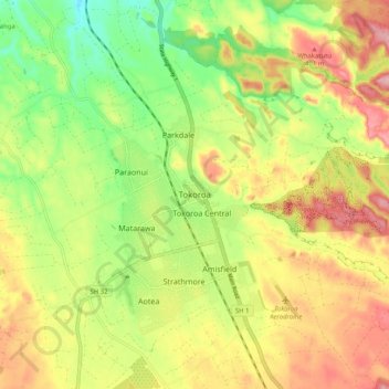
Name: Tokoroa topographic map, elevation, terrain.

Location: Tokoroa, South Waikato District, Waikato, 3444, New Zealand (-38.25687 175.83054 -38.17687 175.91054)

Average elevation: 348 m

Minimum elevation: 269 m

Maximum elevation: 431 m

Other topographic maps

Click on a map to view its topography, its elevation and its terrain.
Arapuni

New Zealand > Waikato > South Waikato District

Average elevation: 194 m

Gear up for your next adventure:

💧Hydration Bladder - Hands-free hydration solution for long treks
🥾Approach Shoes - Shoes designed for climbing approaches and rugged trails
🧢Sun Hat - Wide-brim hat for sun protection
🧢Beanie Hat - Keep your head warm in cold weather
🧰Emergency Multi-Tool - Compact multi-tool for outdoor survival

As an Amazon Associate, this site earns from qualifying purchases at no extra cost to you.