Geolocate

Yokohama topographic map

Click on the map to display elevation.

About this map

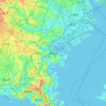
Name: Yokohama topographic map, elevation, terrain.

Location: Yokohama, Kanagawa Prefecture, 〒231-0016, Japan (35.28499 139.47677 35.60499 139.79677)

Average elevation: 22 m

Minimum elevation: -7 m

Maximum elevation: 146 m

Other topographic maps

Click on a map to view its topography, its elevation and its terrain.

Karasawa

Japan > Yokohama

Average elevation: 21 m

Gear up for your next adventure:

🧣Evaporative Cooling Towel - Beat the heat during intense summer climbs
🚲MTB Frame Bag - Carry tools and maps directly on your bicycle frame
🧤Thermal Hiking Gloves - Grip-enhanced gloves for cold-weather altitude trekking
Camping Groundsheet - Protect your tent from moisture and dirt
🧦Hiking Socks - Moisture-wicking and comfortable socks for long hikes

As an Amazon Associate, this site earns from qualifying purchases at no extra cost to you.