
Harsil topographic map
Interactive map
Click on the map to display elevation.
About this map
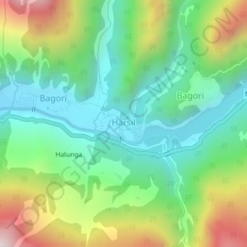
Name: Harsil topographic map, elevation, terrain.
Location: Harsil, Bhatwari, Uttarkashi district, Uttarakhand, India (31.03390 78.74709 31.03965 78.75525)
Average elevation: 2,761 m
Minimum elevation: 2,464 m
Maximum elevation: 3,350 m
Other topographic maps
Click on a map to view its topography, its elevation and its terrain.
Uttarkashi
India > Uttarakhand > Bhatwari
Uttarkashi, Bhatwari, Uttarkashi District, Uttarakhand, 249193, India
Average elevation: 1,619 m
Gangotri Glacier
India > Uttarakhand > Bhatwari
Gangotri Glacier, Bhatwari, Uttarkashi, Uttarakhand, India
Average elevation: 5,259 m
Dharali
India > Uttarakhand > Bhatwari > Dharali
Dharali, Bhatwari, Uttarkashi district, Uttarakhand, India
Average elevation: 2,963 m
Shilla
India > Uttarakhand > Bhatwari
Shilla, Bhatwari, Uttarkashi district, Uttarakhand, India
Average elevation: 2,178 m